
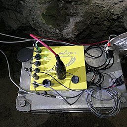
Seismic acquisition system
Distributed DAQLink 4
Nineteen seismic measurement systems Distributed DAQLink 4 from Seismic Source are available for fast seismic data acquisition of up to 486 channels. Reducing the number of channels per system, sampling rates of 64.000 samples/s can be achieved with the 24 bit ADCs. The Distributed DAQLink 4 is a robust cable-based system that allows communication and triggering at distances of up to 3000 m, with maximum data rates up to 240 m away. Thus, long-range measurements are possible even over several levels underground.
The Time Sync Unit (TSU1) is used in conjunction with the registration unit to utilize GPS time accuracy in the underground environment.
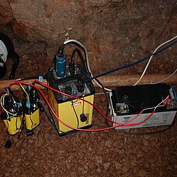
SUMMIT Compact
Four SUMMIT Compact seismic measurement systems are available for seismic data acquisition with up to 96 channels of channels at sampling rates of 48.000 samples/s. The SUMMIT Compact is a robust cable-based system. A 250 m two-wire bus is used for communication and triggering of all measuring systems.
Mobile 3D handheld scanner
ZEB Horizon RT
The integration of precise topographic data into the analysis of cavity geometries such as tunnels, soles, and routes requires advanced technologies. In this context, we rely on GeoSLAM's Laser Hand Scanner. This mobile device enables effortless capture of topographic data along the measurement layout and impresses with a range of features that make it particularly appealing for underground applications.
Its outstanding ease of use ensures that the scanner can be seamlessly deployed in challenging underground terrain, even without a tripod. In environments where GPS signals are often unavailable, the device proves to be highly reliable, as it can conduct 3D mapping even without GPS support.
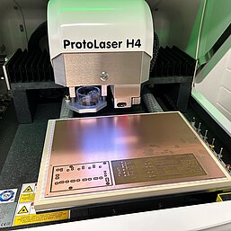
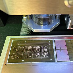
LPKF Protolaser H4
The LPKF Protolaser H4 is a tabletop system for single and double-sided surface processing of PCB materials such as FR4. It has a laser for precise processing of the copper layer, as well as a milling spindle for mechanical processing of the base material such as drilling and cutting. The laser enables more precise and finer structuring of conductive tracks from 100 µm with intervals of 30 µm. This enables miniaturization of printed circuit boards for small applications such as the slimhole probe currently under development.
| Maximum layout area (X/Y/Z) | 305 mm x 229 mm x 7 mm |
| Laser wavelength, frequency, power | 1064 nm, 25-400 kHz, 20 W |
| Conducting path minimum width/spacing | 100 µm / 30 µm auf FR4 18 µm Cu |
| Repeat accuracy | ±1.8 µm |
| Rotation speed cutter spindle | 100 000 rpm |
| Weight | 125 kg |
| Laser safety information | Laser class 1 |
High-performance servers
The efficient processing and imaging of structures in the vicinity of underground facilities require powerful servers, especially for data processing and imaging of seismic data. The 3D structural models are composed of several billion pixels, demanding significant computational power. Three servers with 88, 102, and 192 CPUs are available for this purpose.
3D Printer
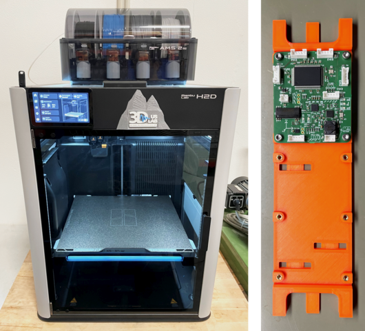
Bambu Lab H2D
The Bambu Lab H2D offers versatile 3D printing capabilities with its dual hotend and enclosed, heated chamber, enabling multi-color and multi-material printing. From cost-effective PLA to chemically and mechanically robust materials such as ABSand PETG, and even flexible filaments like TPU, it supports a wide range of applications. It is used for producing prototypes, mounting components, display models, and even trade fair equipment parts. The build volume of 350 × 320 × 325 mm³ allows for seamless printing of larger components.